New Transportation System Operational (R:1 News): Difference between revisions
MysteryCorgi (talk | contribs) No edit summary |
MysteryCorgi (talk | contribs) m (→Transcript) |
||
| Line 4: | Line 4: | ||
==Transcript== | ==Transcript== | ||
{{R:1 News | {{R:1 News | ||
|news=WEB NEWS | |||
|background= 8dbde1 | |background= 8dbde1 | ||
|title= New Transportation System Operational | |title= New Transportation System Operational | ||
| Line 10: | Line 11: | ||
This system's main feature is the ability to <br>control and adjust traffic lights depending <br>on the situation. It can also predict the best <br>timing at railway stops. When there is a <br>crime, it will turn all traffic lights around the <br>area to red to help prevent the culprit from <br>escaping. Of course, it is questionable <br>whether criminals will follow the traffic laws. <br> | This system's main feature is the ability to <br>control and adjust traffic lights depending <br>on the situation. It can also predict the best <br>timing at railway stops. When there is a <br>crime, it will turn all traffic lights around the <br>area to red to help prevent the culprit from <br>escaping. Of course, it is questionable <br>whether criminals will follow the traffic laws. <br> | ||
}} | }} | ||
==Article Images== | ==Article Images== | ||
Revision as of 00:32, 24 February 2024
(file name: xddn_010.bmp)
(blue banner)
Transcript
{{{header}}}
New Transportation System Operational
 Transportation Control System (RTCS) ended its trial period today, and will be fully operational starting tomorrow. It is predicted that chronic traffic jams will be resolved by this system. This system's main feature is the ability to |
Article Images
-
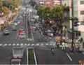
Japanese Version
-
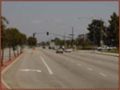
US Version

Notes
The Japanese and English release feature different photos. The PAL version uses the same photo for the Italian language version.
The location of the Japanese photo is unknown, suspected to be Fukuoka, Japan.
The photo used in the US release appears to have been taken from the road median in front of the former Bandai of America offices in Cypress, California circa 2002-2003. Specifically facing East, looking towards the intersection of Katella Avenue and Douglas Dr/Warland Dr. (33°48'10.8"N 118°02'08.2"W)
References
| ||||||||||||||||||||||||||||||||||||||
